Tuesday 30 May 2023


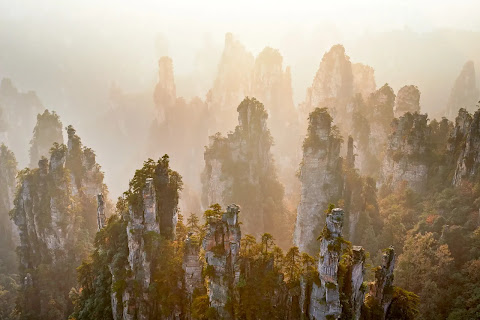
A wonderfull gift from mother nature !

- Wulingyuan Scenic Area, China -

      ( Scenic and Historic Interest Area)


         A spectacular area stretching over more than 26,000 ha in China's Hunan Province, this place is dominated by more than 3,000 narrow sandstone pillars and peaks, many over 200 m high. Between the peaks lie ravines and gorges with streams, pools and waterfalls, some 40 caves, and two large natural bridges. In addition to the striking beauty of the landscape, the region is also noted for the fact that it is home to a number of endangered plant and animal species.
Criterion 

Outstanding Universal Value

         The huge number of sandstone columns and peaks more than 3,000 are spectacular. These, coupled with other land forms (natural bridges, ravines, waterfalls, streams, pools and caves) and dense broadleaf forest, present an aesthetically beautiful landscape enhanced by the mists and clouds which frequently shroud the site. There are more than 40 caves and two huge natural stone bridges, one of which rises 357 m above the valley floor. At time of evaluation it was also noted that with additional information there could also be justification for inscribing this property under criterion (x), as this place provides important habitat for a number of threatened plant and animal species such as dhole, Asiatic black bear and Chinese water deer.

Integrity

         The property has within its boundaries all the necessary elements demonstrating the natural beauty for which it was inscribed, as well as a buffer zone. Integrity issues noted at time of inscription include human pressure from use of the reserve by people living in and around it, and the intense pressure from visitors. Numerous tourist facilities also have an aesthetic impact on the natural values of the property. However many measures have been and are still being undertaken to address these issues.


Protection and management requirements

       Wulingyuan was approved and listed as a national key scenic area by the Chinese State Council in 1988, thus has a long history of protection under relevant national and provincial laws and regulations. In 1999, owing to the growing commercialization and loss of natural values, the local authorities declared the Decision of Protecting Wulingyuan World Natural Heritage Property, and began the demolition of houses in the scenic areas. The scenic area was expanded, settlement was reduced and ecological tourism was promoted. By the end of 2002, the adverse impacts on the aesthetic values of Wulingyuan scenic areas had been mitigated. In January 2001, the Hunan Provincial People’s Congress Standing Committee implemented the Regulations on Protection of Wulingyuan World Natural Heritage Property, providing a stronger legal basis for protection. The property is managed by the Administrative Bureau of Wulingyuan Scenic and Historic Interest Area assisted by several other resource management agencies.

       The Office of Heritage Protection was established in 2000 as the operational agency for managing the property and subsequently the Zhangjiajie, Tianzishan, Suoxiyu and Yangjiajie Scenic Area Offices and Protection Stations were established. In total, there are approximately 500 management staff. Museums and visitor centres have been created for research, education and interpretation of the property’s natural values In 2005, the Comprehensive Plan of Wulingyuan Scenic and Historic Interest Area was revised and Wulingyuan World Natural Heritage protection regulations were established to ensure the long-term protection and conservation of the property. The quartz sandstone peaks, columns, karst landscapes, gorges, species, vegetation, ecology, and all other elements that contribute to be aesthetic value of Wulingyuan need to be strictly maintained and monitored.

       The number, seasonal distribution and activities of visitors is scientifically controlled and adjusted so that a dynamic balance between World Heritage, people and the economy is established. In order to deal with the challenges of tourism development and environment protection, special organizations have been established which monitor all the elements contributing to the aesthetic value of the property cited .
Monday 29 May 2023

Mother Nature has created a land full of natural beauty in the Atlantic Ocean. THE AZORES , PORTHUGAL .


Mother Nature has created a land full of natural beauty in the Atlantic Ocean.

THE AZORES , PORTHUGAL


        Roughly 900 miles off the coast of Lisbon, this Portuguese archipelago can inspire wanderlust with a single photo. The verdant valleys, steep oceanside cliffs, rows of blue hydrangeas, and scattering of waterfalls make the Azores a paradise worth exploring.Azores, Portuguese in full Arquipélago dos Açores, archipelago and região autónoma (autonomous region) of Portugal. The chain lies in the North Atlantic Ocean roughly 1,000 miles (1,600 km) west of mainland Portugal. It includes nine major islands. The Azores are divided into three widely separated island groups.The eastern group, consisting of São Miguel, Santa Maria, and the Formigas islets.the central group, consisting of Faial, Pico, São Jorge, Terceira, and Graciosa; and the northwestern group, consisting of Flores and Corvo. The capital is Ponta Delgada on São Miguel. Includes Azores and Madeira Islands. Includes locator.

         The nearest continental land is Cape Roca, Portugal, which lies 875 miles (1,400 km) east of Santa Maria. The Azores, rising from the ocean atop the Mid-Atlantic Ridge, are in effect a major mountain range. The islands rise steeply from shores lined with rock and pebble debris (scree, or talus) to heights reaching 7,713 feet (2,351 metres) above sea level on Pico, the highest point in metropolitan Portugal. Their unstable geologic nature is indicated by numerous earthquakes and volcanic eruptions. In 1522 the town of Vila Franca do Campo, then capital of São Miguel, was buried during a massive convulsion, and as recently as 1957–58 the Capelinhos eruption enlarged Faial. Indeed, many island houses are constructed of building blocks made of basalt. Deep craters (calderas) as well as lakes are a dramatic feature of the islands. On São Miguel the volcanic heat on the shores of Lake Furnas, a popular picnic spot, is sufficient for cooking.

         The Azores have a subtropical climate with high humidity. An abundant flora of European and Mediterranean origins is found there, and mixed forests still cover many of the islands’ hillsides. Intensive agriculture produces cereals (wheat and corn , maize), vegetables, and fruit (including pineapples and wine grapes). The vineyard culture of Pico Island was designated a UNESCO World Heritage site in 2004. A high-quality cured cheese is made at São Jorge. Among the other principal products of the Azores are various dairy products, fish, pineapples, and wine. São Miguel is home to two of the only tea plantations in Europe, and both sites offer visitors a glimpse of the island’s traditional tea-making process. A free-trade zone has been set up on Santa Maria. The scenic beauty of the islands draws visitors in increasing numbers. One of the prime tourist activities is whale watching (whaling ceased in 1984). Some 20 species of cetaceans can be viewed.

         The inhabitants of the Azores are mostly of Portuguese origin and predominantly Roman Catholic. A high density of population and limited economic opportunities provoked extensive emigration, mainly to the United States and Canada, from the end of the 19th century well into the 20th century and has not entirely ceased. The islands’ isolation has diminished, and communications have considerably improved. Every island has an airport or airstrip. The principal seaports are Angra do Heroísmo (or Angra), Ponta Delgada, and Horta. Lajes and Santa Maria became important air bases and centres of communication between the United States and Europe during World War II. since 1951, by agreement with Portugal, the United States has maintained a North Atlantic Treaty Organization (NATO) air base on Lajes. Before the development of weather satellites, meteorological data compiled in and transmitted from the Azores were essential to European weather forecasting.


    BEST 06 PLACES TO TRAVEL ON A BUDGET       T he world is full of cheap vacation spots. And, these days, it doesn’t require much effort t...